On April 8th, 2024, a total solar eclipse will sweep across North America, from Mexico to the Maine-Canadian border. For those who experienced the spectacular solar eclipse of 2017, this one will be similar, crossing the United States from west to east and passing...
For those of us here in Illinois, the end of January this year was mind-blowingly frigid. Wind chills dipped as low as minus 50-60 degrees Fahrenheit in parts of the upper Midwest, and in Chicago it was not much warmer than that. In fact, temperatures that week were substantially colder in the states along the Great Lakes than in the world’s northernmost permanent settlements on the island of Spitsbergen in Norway, where daylight will be returning this month for the first time since October. Whenever temperatures get lower than normal here in the US, there are many people (our president included) who question the existence of climate change.
As discussed in a post here on Science Unsealed last year, however, it is important to remember that the global warming behind climate change refers to the long-term trend in the average temperature of our planet as a whole. So while winter temperatures dipped lower here in the US than ever before, summer temperatures in places like Australia soared to record highs, where bats dropped dead from the trees by the thousands as a consequence of an unprecedented January heatwave. Additionally, some of the latest research on climate change suggests that a warming planet may actually trigger regional cold snaps like the one we just experienced. To understand why, let’s explore the circumstances that led to our most recent polar vortex.
So what is the Polar Vortex?
For those of us who may be unfamiliar with the jargon used by climate scientists, the term polar vortex may sound like some kind of frightening supervillain out of a Hollywood movie! Even though the sound of it is something quite atrocious, polar vortices are whirling around over the Arctic and Antarctic all the time. Technically speaking, a vortex is simply a mass of gas or liquid that swirls around a center point. Hurricanes and tornadoes are two such examples. Polar vortices, in particular, are vortices that happen to form in the cold air near the north and south poles.
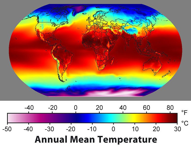
The average near-surface air temperature (sea surface temperature over the oceans) of the Earth for the period from 1961-1990.
Credit: Data from a variety of sources, compiled by Robert Rohde
A polar vortex forms due to two key factors – the rotation of the Earth and the temperature gradient between the equator and the poles. Climate scientists use the term gradient to talk about the change in temperature as one moves from the equator to either pole because the temperature changes gradually over that distance. Because the areas near the north and south poles receive less sunlight than the areas near the equator, polar climate is much colder than tropical climate. Additionally, since hot air has a higher pressure than cold air, the heat from the equator naturally flows towards the poles.
Here’s where things get interesting! When Earth spins, our atmosphere spins with it. However, because the Earth is wider near the equator than at the poles, the ground and the air at any given spot near the equator has to circle around a longer distance over a day as the planet rotates, so the air near the equator is actually moving faster than the air near the poles!
As the temperature gradient causes this air to move toward the poles, it continues to move at its original speed while the ground below it gradually gets slower compared to the ground at the equator. When this happens, the winds that were once at a lower latitude get faster compared to the ground below, and like water circling around a drain, these winds swirl around the planet in rotating bands called jet streams. This is called the Coriolis effect. The polar jets are the strongest jet streams, and they hold the polar vortices in near the poles and away from us most of the time.
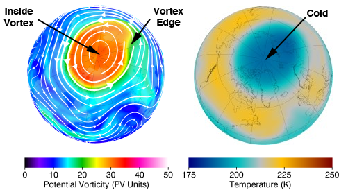
Airflow over the north pole and the frigid cold that it contains. From NASA’s Goddard Space Flight Center.
To visualize the Coriolis effect for yourself at home, try printing a map of the northern hemisphere and pinning it at the north pole in the center. While spinning the map steadily, use a pen or pencil to trace a straight line from the equator to the north pole, being careful not to move with the map as it turns. What you will see is that the “line” you draw actually curves on the map because the edges move faster than the center.
What causes a polar vortex to dip into the Midwest?
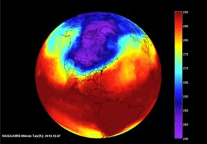
NASA’s AIRS captured this view of the polar vortex that reached Chicago in 2013. Click the image to see a time-lapse video.
During the winter, the polar vortex naturally expands into lower latitudes as temperatures cool over the hemisphere as a whole. But even in the coldest winters, the Arctic air within the vortex does not dip down past the great lakes that frequently.
If the polar jets are weaker than usual, however, they tend to meander in more of a zig-zaggy path because air can better circulate directly between equator and poles. When this happens, warm air from the south pushes its way into to the arctic, displacing the cold air in the vortex, which has no choice but to travel south. Without a strong jet stream to hold the polar vortex together, all that cold air up north breaks off in globs as if the atmosphere were a giant lava lamp!
What can we expect in the future as a result of climate change?
If it seems like these unwelcome blasts of Arctic weather into the Midwest have grown more frequent, you’re right. The research is still developing, and the link is still subject to active debate among climate scientists, but some scientists say that climate change may have a role. Recall the two most important factors that create the jet stream and the polar vortex: Earth’s rotation and the temperature gradient between the poles and equator. Through a phenomenon that scientists call polar amplification, the Earth’s warming is most drastic near the north and south poles – the Arctic, in particular, has been warming at twice the rate of the globe as a whole! This means that the temperature difference between the equator and the poles has been decreasing, thereby dampening the flow of heat from the equator to the poles. Since air has to circulate towards the poles to form our jet streams, these polar changes could be weakening the polar jets and allowing the cold air within it to break away from the arctic more frequently and dip into lower latitudes. So while winters may be getting warmer on average, don’t plan on ditching your heavy coats any time soon!
Further Reading:
- NOAA: The Science Behind the Polar Vortex
- Vox: The Midwest is Facing Record-Breaking Cold. Blame the Polar Vortex
- Illinois Science Council: Why Do We Get Cold Weather When the Climate Should Be Warming?
- NASA: NASA’s AIRS Captures the Polar Vortex Moving Over the US
- New York Times: Polar Vortex 2019
- New York Times: Why is the Cold Weather So Extreme if the Earth is Warming?
- PBS: Think You Know the Polar Vortex? Think Again
Nathan Baskin is a freelance science writer who graduated from the University of Chicago with a Master’s of Science in the Geophysical Sciences. You can follow him on social media @NathanJBaskin on Instagram and Twitter, and you can learn more about his latest work on his website.