On April 8th, 2024, a total solar eclipse will sweep across North America, from Mexico to the Maine-Canadian border. For those who experienced the spectacular solar eclipse of 2017, this one will be similar, crossing the United States from west to east and passing...
We have our next Ask a Scientist question, brought to us by Susan F., a 1st-grade teacher who wanted to know more about how our weather forms. Here’s Susan’s question:
How do thunderstorms form?
Imagine it’s a warm, sunny, summer day here in Illinois…the temperature is in the 80s, and the air feels thick and humid (this might be hard to imagine in March, so take a minute if you need to). Maybe you’re at the park, at the beach, or maybe you’re just in your backyard enjoying a tall, cold glass of iced tea. You barely notice the white, fluffy clouds becoming bigger and bigger through the afternoon. Then suddenly, the world seems to dim a little. You glance to the west and notice a giant, dark cloud approaching. Uh oh…time to head inside. You watch out the window as the sky goes dark, the wind picks up, and the downpour begins, accompanied by lightning and thunder…hopefully you saved something for a rainy day.
So how does this change in the weather happen? Well, it starts with the formation of clouds. Let’s think about what was happening earlier that day. The sun was heating the ground, which was in turn heating the air near the ground. The warmer air near the ground becomes lighter and less dense than the air above it, so the less dense air begins to rise. This effect is called buoyancy. You can picture buoyancy more easily if you think of a hot air balloon. Heating the gas inside the balloon makes it less dense and lighter than the air around it, so buoyancy makes the balloon rise. In a similar way, the warm summer air near the ground starts to rise. Or, as is common in Illinois, a large region of cooler air begins to move into the area (usually from the west), causing the warmer air that was already there to rise as the cooler air moves in.
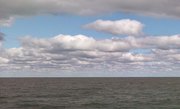
Photo 1: Clouds often start to form at a specific height.
The warm summer air near the ground is also humid, meaning there is a large amount of invisible water vapor in the air. In fact, the warmer the air is, the more water vapor it can hold. This pocket of warm, humid air continues to rise high above the ground. As our warm pocket of air rises higher and higher, less pressure pushes on it. One way to picture this is to think of yourself at the bottom of a swimming pool. When you’re at the bottom, you can feel the pressure of the water in your ears. As you swim up to the surface, the pressure eases. In a similar way, as our warm pocket of air rises, the pressure eases off of it, and it can push to expand itself. This pushing and expanding causes it to lose some energy, which makes it cool down.
The air keeps rising, expanding and cooling as it goes. Eventually, it cools to a particular temperature where it cannot hold all of its water vapor anymore. So the invisible water vapor leaves the air to become visible water droplets. We see these droplets as a cloud! Take a look at Photo 1 taken in Evanston, Illinois. Have you ever noticed that puffy clouds like this are often flat on the bottom? You can see the exact height when the water leaves the air and forms a visible cloud.
Sometimes, this is the only kind of cloud that forms and you just have another nice summer day. But what if there is much more rising humid air? These clouds can continue to build. Check out these clouds in Photo 2. Some of these clouds are starting to build and become taller.
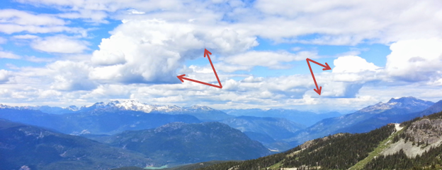
Photo 2: Under the right conditions, clouds can build and become taller.
As the cloud grows, the droplets inside the cloud can grow bigger and bigger. If they become big and heavy enough, they fall as rain. So if it’s raining, it just means that the cloud is emptying its water back onto the ground! But even as it rains, these clouds can build into towering giants, like this cloud in Photo 3. Huge clouds like this block out much of the light from the sun, so it can get quite dark during a thunderstorm.

Photo 3: A towering thunderstorm cloud visible from many miles away
But what about the lightning and thunder? Well, have you ever gotten shocked when you reached out to touch a doorknob? When you walk across your carpet, the motion between your socks and the carpet can build up a slight electrical charge in your body. When you touch the doorknob, the charge equalizes, and you can often see a small flash and hear a pop. In a similar (but much bigger) way, charges can build up in different parts of a thunderstorm cloud or on the ground. When enough charge has built up, it can be suddenly equalized with a bright flash and a loud boom. We see and hear this as lightning and thunder, respectively. Lightning can strike between two parts of a cloud, or it can strike between the cloud and the ground.
You might have noticed that you sometimes see the lightning before you hear the thunder. This is because the light you see travels much faster than sound you hear. When lightning strikes, you see the flash almost instantly, but you might have to wait a few seconds before the sound of the thunder reaches your ear. For this reason, the farther away the lightning strike occurred, the longer you have to wait to hear the thunder. In fact, you can easily figure out how far away a lightning strike is by counting the number of seconds between when you see the lighting and when you hear the thunder. For every five seconds between the flash and the boom, the storm is one mile away. So, divide the number of seconds you count by five to get the number of miles.
Eventually the thunderstorm runs out of warm, humid, rising air, and it slowly becomes gentler. The last of the rain falls, and the thunderstorm disappears…until next time!
-Andy Mayka, mechanical engineer
Do you have a science question that you’d like answered by a scientist? Ask it here! We’ll send you an answer and post our favorite questions on our blog!
Sources
- Musk, Leslie F. Weather Systems. Cambridge: Cambridge UP, 1988. Print.
- Reynolds, Ross. Guide to Weather. Buffalo, NY: Firefly, 2005. Print.